Monday, October 11, 2010

Sikles Circuit( outside pokhara )


Sikles is another big Gurung village. It is 24 km north-east of Pokhara. It is situated at an altitude of 1,981m. There are many routes to reach Sikles which is only three days away from Pokhara. But it is best to travel via Ghalekharka. This route is designated as eco-trek route by Annapurna Conservation Area Project (ACAP) and the infrastructure required is already made.

The route takes three days to reach Sikles. From Pokhara there is facility of vechicles usually upto Puranchowr and it is better to start your trek from here. The trail leads through the cultivated land and the climb is gentle. After a walk of seven to eight hours you will be able to reach Ghalekharkha. At Ghalekharka, there is a camp site designated by ACAP where you have to lodge.

All the way you have to walk through villages so there are facilities for food but there are strict rules as you are following eco-trek route; so you are not allowed to throw rubbish as you like. There are several rubbish bins and also lavatories on the way.

As soon as you are in Ghalekharka, you will find ACAP check post and you will get futher information there. After Ghalekharka, the trail passes through dense forests and theere is not any house or hotels in between Ghalekharka and Sikles but a camp site at Nyaulikharka where you will spend your second night. The trail rises upto 2,750m.

Third day, you have to continue your walking through dense forests and reach either Parche or Sikles for cmaping. There is one natural History Museum managed by ACAP. The village is facilited by the eletricity.

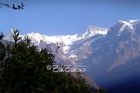
This snap features the pyramid view of Mount Fishtail (Machapuchhere) on the way to Sikles. Sikles is a gurung village and is worth a visit.

You can return to Pokhara via Thak and it is also two days walk and so you better halt at Thak and start the trek next day towards Pokhara.

Jomsom Route ( outside pokhaa)


Trek to the Annapurna Himalayan range starts from Baglung but there is another route too.

Jomsom trek can also be started from Baglung Bus Parkin Aarchalbot. An hour bus ride will take us to Nayapool from where we start walking uphill towards a gurung village known as Ghankruk. Including this we can also take a direct flight to Jomsom from Pokhara. It is just 20 minutes flight from the Pokhara airport to Jomson. Some people do prefer flight and trek all the way back to Pokhara.

A caravan of horses and carrying donkeys going towards Kagbeni which is a 5 hour walk from Jomsom for normal walking people. This is the main source of transportation in this region. The river shown in the snap is River Kali Gandaki known to be the sister of Seti river. The difference is Seti river is white and Kali is black. In Nepali language White means Seti and Black means Kali.

Pony Trek outside pokhara


With the landscape varying from the even lakeside to small hills with the most famous view in the country, Pokhara provides a magnificent opportunity for sightseeing on horseback.Pokhara, the clean and serene city beautifully located, is rich of many lakes rivers and the great view of mountains.

Our programs:
We will take a packed lunch or some sandwiches and fruit and have it with a relaxed time. We will linger in the rice fields, wonder at the haunting views of Lakes Mountains and green forest and enjoy the shy smile of a passing beauty.

Pony trek around Pokhara Valley
• Damside-Dobilla-Nirmal Pokhari-Bhandardhik
• Damside-Dobilla-Nirmal Pokhari-Kristi-Davis Fall
• Davis Fall-World Peace Pagoda –Pumdi Bhumdi –Machapuchhre View Point
• Pokhara –Pame –Thulachaur – Pokhara
• Pokhara-Sarangkot-Kaskikot-Naudanda
• Pokhara-Methlang/Gyarjati-Pokhara
• Pokhara-Dhampus-Pokhara

Panchase Trek out side pokhara


This trek is probably the best short trek with good Mountain View. The combination of culture and rich flora and fauna with the majestic view of Annapurna and Dhaulagiri makes this trek very typical one. Very few places in the world have such a splendid variety of natural beauty. A rare combination of snow-capped peaks, crystal clear lakes, and turbulent rivers with deep gorges, together with Tibetan monasteries, hot springs and picturesque villages are the significances of this trek.

Annapurna Region Trek


Introduction:
"Trekking in the Annapurna Himal will open your eyes not only to scenes of great beauty, but will enable you to build relationship with people of another race another culture"
-Kev Reynolds
Author- Annapurna "a trekkers guide"

Spectatcular view from the beautiful lake city Pokhara in central Nepal the northern horizon, about 30 kilometres(20 miles) away, is well of glittering snowy peaks of the Annapurna mountain. Magical changes of the colour with sunrise and sunset, one can feel the deep enchanment of these glorious mountain. Among them twelve summits rise in excess more than 6000 m(19500 ft.) high. It's an island block moated on the east by the eleft of the marsyangdi khola and the west by the deep Kali Gandaki valley. To the frontier ranges which from the northern wall of the curving marsyangdi rises manaslu (8163 m) and to the west of the Kali Gandaki the dramatic Dhaulagiri Himal crowned by the shapely ice peak, of Dhaulagiri itself, while draining the heart land of thus huge block of mountain is the deep shaft of Modi Khola.

Apart from the mountains, the Annapurna region is popular for it's geographical and cultural diversity. The "heriefy" of the scenic beauty from the green lush vegetarian of the lowlands where rice paddies terrace the foothills to arctic-like saragery of ice falls and gleaming glaciers and will surprise the new comer to Nepal with the broad smiles and genuine open hearted friendliness of the local people. Namaste namaste in their eyes and on their lips is respect and a welcome to their guest.

If it is a dream of mountains that initially lures you to this himalayan kingdom. It will be the valleys and hillsides populated by a wide range of rthnic groups, each united by a common bond of traditional Nepalese hospitality and cheerfulness that ensures you do not forget it. Among the Annapurna massif the cultural diversity the ethnic variety, is probably greater than anywhere else in all Nepal. A rich and memorable experience indeed awaits all prospective trekkers in the Annapurna Himal.

Seti Rivers at pokhara


Stretching from east to west, the breathtaking views of the world famous Himalayan range of the Annapurna, Dhaulagiri, Machhapuchhre and others appear so close as to make you feel that you can almost touch them. Sarangkot, Kaskikot, Kalikasthan, Bharat Pokhari and the Bhumdi Hill command beautiful views of the valley and the mountains. These places are also vantage points to view sunrises and sunsets over the majestic Himalayan peaks. The Photo here shows a River below Kau Danda which is popular for fishing purposes. It is a glacial river that flows from the Annapurna Himalayan region.

Kahun Danda is a hill at 1,433m high, and is two hours walk from Mahendra pool. Like other places this place also offers pleasing view of Annapurna range and flat terraces of Pokhara. On the top of the hill is a tower constructed for a clear view of the valley and the Himalayas. There is a fortress and a temple on the top.

A unique river passing through two beautiful and contrasting scenic areas. This river is relatively small in volume, blue and warm, it is recommended as a warm-up river for intermediate rafters, Kayakers and kayak clinic. The Seti Khola rises on the south-east slopes of Machhapuchhere and then flows south .

Location of Pokhara valley

Pokhara valley extends, in the 'Oriental Realm', between the north parallels of 250 7’ and 280 10' and east meridians of 83050' and 84050'. Situated in the mountainous region of the southern Himalayas and trapped between the higher Himalayas in the north and Mahabharat range in the south, it occupies central position in the country. It valley spreads mainly over Kaski district and covers small portions of Tanahun and Syangja district from Pokhara, Tibetan border to the north is 72 kilometers and Indian border to the south is 78 kilometers. Within a small area the elevation ranges nearly from 500 meters to 3,000 meters in the Pokhara valley.

Based on the administrative division on hierarchical order Pokhara lies in Western Development Region, Gandaki Zone and Kaski District. The valley includes Pokhara Sub‑Metropolitan City', Lekhnath Municipality, and some other Village Development Committees. The city is located in the central part of the valley. An amazing city, However, you can still access such entertainment via internet if you wish, after a day of enjoy the natural splendors of the valley. Happy travels!

Thalajung Village


Its perfect hilly location, natural setting, good weather makes this place very suitable for the development of village tourism, tea and coffee plantation, a resort town, and a gateway to trekking in Manaslu conservation area.